![]() Data
Data
Digital Raster Graphics (DRGs)
Digital Elevation Models (DEMs)
![]()
![]() Data
Data
Digital Raster Graphics (DRGs)
Digital Elevation Models (DEMs)
![]()
![]() Trinity River Basin
Trinity River Basin
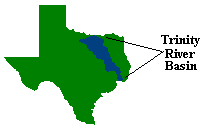
The Trinity River Basin is located in East Texas and has approximately 18,000 square mile area. In the northwest part of the basin the altitude is 1,200 feet and the terrain varies from hills and valleys to prairies with grasslands and farms. The central part of the basin is hilly, while the lower part is plain. The Trinity River opens into the Trinity Bay and from there the water flows into the Galveston Bay which opens into the Gulf of Mexico.
The basin can be seen on the following map of Texas:
The flow in the rivers in the Trinity basin is highly dependent on rainfall. Most of the river flow is rainfall runoff and between rains the flow is therefore often quite low between rains. Lack of natural flow in dry periods makes the river vulnerable to pollution since during those periods, a large part of the flow in the river comes from discharge of wastewater.
The main purpose with the TMDL project is to find out where pollution is more than can be allowed, to find the source of the pollution and to find a way to diminish the risk of pollution. To trace where the contaminants come from, a river network has to be constructed and important point layers have to be associated with it.
The most important point data layers that have to be connected to the river network can be seen on the following picture:

The
blue points are discharge points; i.e. points were discharge of wastewater has been allowed. Everyone who discharges wastewater here in Texas has to have a permission to do that from TNRCC and the number of locations where discharge is allowed is 573 in the Trinity Basin.The
red points are water rights locations. While the groundwater here in Texas is considered to be the private property of the owner of the land above, the surface water is regarded as a public property and can only be used with permission from the state. An exception from that is the use of surface water for livestock and household, for people who live near a river or a lake. The permissions are called water rights and the corresponding points are 706 in the Trinity Basin.The
green points are water quality segment points. Water quality segments are the parts in which rivers and lakes are divided for the purpose of monitoring the quality of water as a whole for each part. If the water in a segment fails to meet water quality standards, the segment will become a part of what is called 303d-list and a procedure to clean this segment has to be defined. The most downstream point of each segment is on the picture here. Those are the points I’ll delineate the watersheds for. They are 42 in the basin.The black points are the USGS discharge monitoring stations; it is locations where the amount of water flowing in the rivers is measured (cubic meters or feet per second). They are 140 here.
The
purple points are surface water quality monitoring stations. As said before the water in each segment is supposed to meet certain standards and in those monitoring stations the quality of the water is measured. The measurements consist of evaluating the amount of metals, toxic substances from pesticides and industrial chemicals, fecal coliform bacteria, dissolved oxygen and dissolved solids such as chloride and sulfate in the water. The monitoring stations are 624.
![]() The River Network
The River Network
The river network built for the watershed delineation in the Trinity River Basin is based on the EPA River Reach File 3. A River Reach file is a hydrographic database of surface waters, which defines a connected stream network. The three versions, available now, of the Reach File are RF1, RF2 and RF3, they were created from increasingly detailed sets of hydrologic data produced by USGS. Furthermore the USEPA took those data sets and assigned each river segment, "reach", a unique reach code and added various attributes to the data sets
The main characteristic of the RF3 file is that the river network is divided into 3.2 million stream segments, called reaches, and each segment has a record in the attribute table. One of the fields in the attribute table is called "Reach type". This is a one-character code that tells us whether this particular segment is representing a lake, coastline, waterfall, regular river, braided river etc. According to the Technical Reference for the RF3, the valid reach type codes are as follows:
However, for the purpose of delineating watersheds a network with as much details as RF3 is not suitable. Therefore only three reach types were used from the RF3 file and a centerline coverage was added to the network. The centerline coverage is a set of interpolated line transport paths through all the water bodies, i.e. a single line instead of a braided river and lines through the lakes.
![]() Digital Raster Graphics (DRGs)
Digital Raster Graphics (DRGs)
For better understanding of the river network it is good to use DRGs, scanned images of USGS topographic maps, available at TNRIS. The Texas Natural Resource Conservation Commission (TNRCC) has developed DRGs for the entire state of Texas and they are available for the 1:24,000, 1:100,000 and 1:250,000 topographic map series.
![]() Digital Elevation Models (DEMs)
Digital Elevation Models (DEMs)
A Digital Elevation Model consists of a sampled array of elevations for a set of regularly spaced points. The most accurate DEMs, available for all of Texas are 90m DEMs, however a set of 30m DEMs (more accurate than 90m DEMs) is supposed to be ready soon.
90m DEMs, sometimes called 1-Degree DEMs are available for most of USA in one degree latitude by one-degree longitude maps. They are based on cartographic sources, 1:24,000 scale through 1:250,000 scale maps, and photographic sources. The DEMs elevations are referenced horizontally on the geographic coordinate system of the WGS 72 or WGS 84, while the elevations are in meters relative to the National Geodetic Vertical Datum of 1929. Spacing between points is 3-arc seconds or approximately 90m (changes with latitude), therefore there are 1201 elevations point per profile in a one-degree map.
30m DEMs, or 7.5-Minute DEMs are not yet available for all Texas but they are supposed to become accessible soon! They are derived from digitized map contours and a scanning of NAPP or NHAP program photographs. Each map is 7.5-minute quadrangle with 30m spacing between points; therefore the number of points in a profile varies with latitude. They are generated by using a UTM Cartesian coordinate system as a base for the profiles, while elevations are either in meters or feet referenced to the National Geodetic Vertical Datum of 1929.
![]()