-
This standard came about through the Federal Information Processing Standard #
173. It is a National standard for data exchange used by U.S. Federal
agencies to make data available to state and local governments as well as the
general community. It was designed to transfer databases between different
computing systems while preserving meanting and minimizing the need for external
information describing the data. (ESRI - Arc/Info Help - Located under SDTS in
the Index)
-
"SDTS is a large starndard composed of smaller, more limited subsets that are
federally approved as part of the SDTS FIPS 173 standard. These subsets are
called profiles. The Topological Vector Profile designed specifiacally for
vector data with topology is the only profile supported by SDTSIMPORT." (ESRI
- Arc/Info Help - Located under: Master Contents/Command Refrences/ARC/
Commands/SDTSINPORT)
Take a look at my stuff:
 |
Arc Usage for SDTS in ArcInfo:
Usage: SDTSIMPORT (in_transfer_prefix) (out_cover) {out_point_cover}
- {layer_name} {DD | DROP_DD}
(in_transfer_prefix)
a four character prefix common to all files in the SDTS transfer. The prefix
may include a pathname to a directory. If no directory pathname is given the
files in the transfer will be read from the current work space.
(out_cover)
is the name of the ARC/INFO polygon coverage that will be created.
Here is an example of what happens when you want to make the above files into coverage.
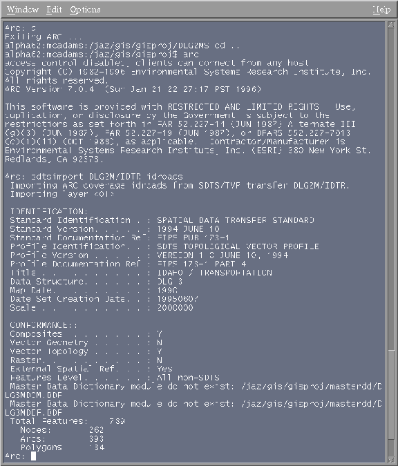 |
That is what it should look like. And the data from it is put into a folder named idroads. Projection parameters are usually contained within the data structure. If you do a describe and you don't find what you want then you should look in the *XREF.DDF file.