Forestry in the state of Idaho has increased dramatically over the last decade. This extensive
increase in "Forest Management", as it is called, can be attributed to two causes. First consumer
demand has increased. Second, controversy over forestry practices in the pacific north west
has driven cutting inland. A Geographic Information System presents itself as a powerfully
efficient tool for the analysis of forest lands, on both the large and small scales.
The forests of Idaho are a massive natural resource. Much of the forest in this state is managed
by the United States Department of Agricultures’(USDA) Forest Service. "Approximately two-thirds
of the forest lands in Idaho are federal lands, almost all in the National Forest System", said
Jay O'Laughlin of the University of Idaho. The National Forest Service (NFS) works along with
private corporations to make use of the natural resource that is entrusted to them. My project
hopes to incorporate some of the most obvious variables related to the analysis of a forest in a
GIS.
Idaho is a candidate for a relatively trouble free GIS forest analysis. The NFS and Bureau of
Public Lands (BPL), and private timber companies hold a large portion of Idaho’s land mass,
therefore, much of the state is potentially available for forest management. Population centers
in the state (Boise and Pocatello; Coeur d’ Alene being the exception) are generally located in the
southern part of the state where forests are less dense. These factors all contribute to the
notion, or assumption, that a large portion of Idaho is potentially "manageable".
Forestry Background
There are many different ways to "harvest" a forest. The two most widely known are clear cutting
and selective cutting. Selective cutting, in general, involves removing specific trees from a plot
of land while leaving a number of trees behind. Clear cutting removes all or nearly all of
the trees from a plot of land. This method, in many cases, is much more economically feasible
and hence the primary method of choice.
State and national laws place restrictions on forest practices. These limitations attempt to
protect both the human and ecological systems around the cut forest.
As a hypothetical example let’s say for a minute that no restrictions were placed on forest
practices. In the shorthanded point of view it would be most economical for a timber company
to remove all of the trees from a large continuous area. This certain area would in most cases
be adjoining former cutting grounds. The simple rule of economies of scale could lead one to
this conclusion. Other reasons include: Forest equipment would only have to be mobilized once.
Only one or two substantial roads would need to be constructed and when the area was exhausted the
roads would not need to be maintained.
Well, this might not sound like a bad idea, but the other side must be looked at. After
our hypothetical region has been exhausted of its timber very few trees will be left. Basic
hydrology and soil conservation information reveals that tree removal predisposes the soil to
significant erosion. In addition, rainfall formerly held and transpired by the trees,
now has no choice but to flow into streams and then rivers. In fact if the area is large enough
the extra water that enters rivers can lead to sever flooding, like northern Idaho has been
experiencing over the past few years. Potentially the largest problem revolves around the now
barren forest. Where will new trees come from? All the mature, seed bearing trees are gone.
The forest will either need to be replanted or regeneration will occur naturally very slowly.
Other problems include stream/river siltation, or increased turbidity, increasing water
temperatures, and loss of animal habitat.
Now that the hypothetical example has been examined, one can see that certain restrictions are
needed to protect both the human and forest ecosystems. Restrictions involving roads and road placement,
clear-cut size, forestable slopes, forestry around streams, around rivers and roads and many
others have all been implemented.
A summary of Idaho’s Best Management Practices (BMP’s), directly pertaining to this forestry
analysis follow:
1. Slopes exceeding 45% grade can only be forested by aerial methods - e.g., Helicopter
2. Class I streams (fish bearing streams) are required to have a buffer zone of 75’.
3. Class II streams (small headwater streams) are required to have a buffer zone of 30’.
Although these are actual laws in Idaho other laws or rules can preempt them. In some cases 75’
of buffer zone is not enough, in others it is more than enough. Correspondence with Ms. Sharon Gray
of the University of Idaho clarified some of the current laws. She mentioned that trees can
actually be cut from the 75’ buffer zones but a shade requirement for the stream needs to be met.
The "requirements [are] for 75% of current shade" over the stream and "a minimum number
of...trees" need to be left dependent on stream width and tree diameters found within the 75’
buffer zone (Idaho BMP’s, 1996 and Idaho Forest Practices Act, 1996).
Some National Forests have different BMP’s. Ms. Gray went on to say that "buffer strips for these
lands [NFS lands] are currently regulated by interim agency guidelines called PACFISH and INFISH,
calling for 300-foot no-cut buffer zones on each side of fish-bearing streams and 150-foot buffers
on other streams. Site-specific buffers and timber harvesting may be implemented after land
managers perform [a] "watershed analysis", a process in its infancy."
In addition to the BMP’s, forest management zones commonly incorporate a buffer zone along major
roads to preserve aesthetic beauty (Maine BMP’s, 1992).
Projections
Because growing trees can be quantified in a aerial manner the decision was made to use the Albers
Equal Area projection for this analysis. While distorting shape, Albers is known to give accurate
results for area based calculations. All analysis was done with data projected to the following
parameters:
Projection ALBERS
Datum NAD83
Units METERS
Spheroid GRS1980
1st standard parallel 29 30 0.000
2nd standard parallel 45 30 0.000
central meridian -96 0 0.000
latitude of projection's origin 23 0 0.000
false easting (meters) 0.00000
false northing (meters) 0.00000
The only exception to the above parameters was a 1:250,000 Digital Elevation Map which was in the
WGS84 datum. Correspondence with Mr. David Maidment of the University of Texas concluded that the
two different datum’s were similar enough to ignore the difference.
Analysis Methodology
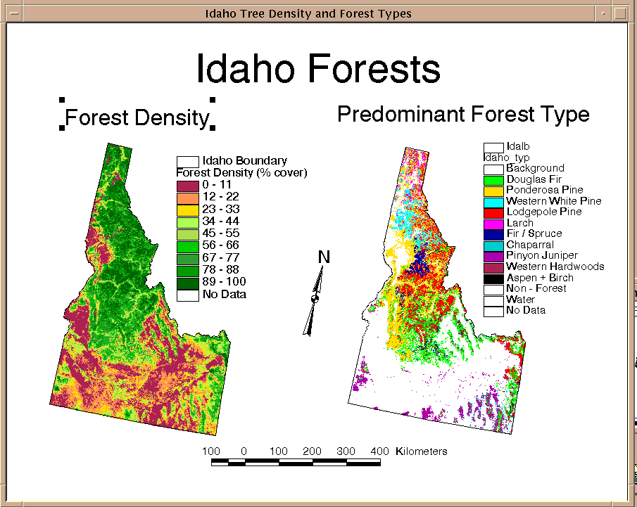
This study will incorporate many different data sources. Beginning with a forest density map for
Idaho, one can start the process of determining which lands are legally available for
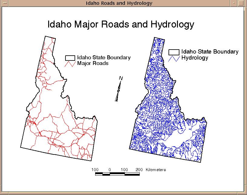
management. Roads and hydrology data are removed along with their corresponding buffer zones from
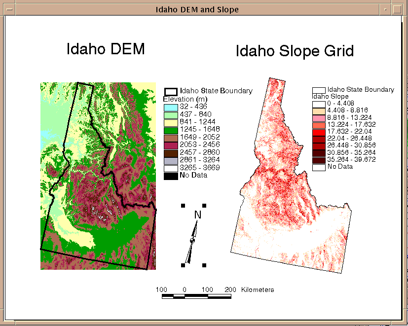
this density map. From an elevation map one can generate slope data, and from this slope map, exclusion
slopes are removed from the same forest density map. Other large land areas that are not available
for management include National and State Park lands, wilderness areas, and private land holdings.
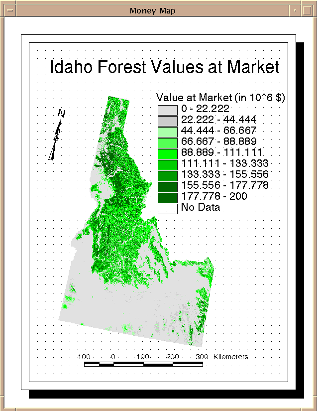
These are also removed from the forest density map. When the final forest density map is compiled,
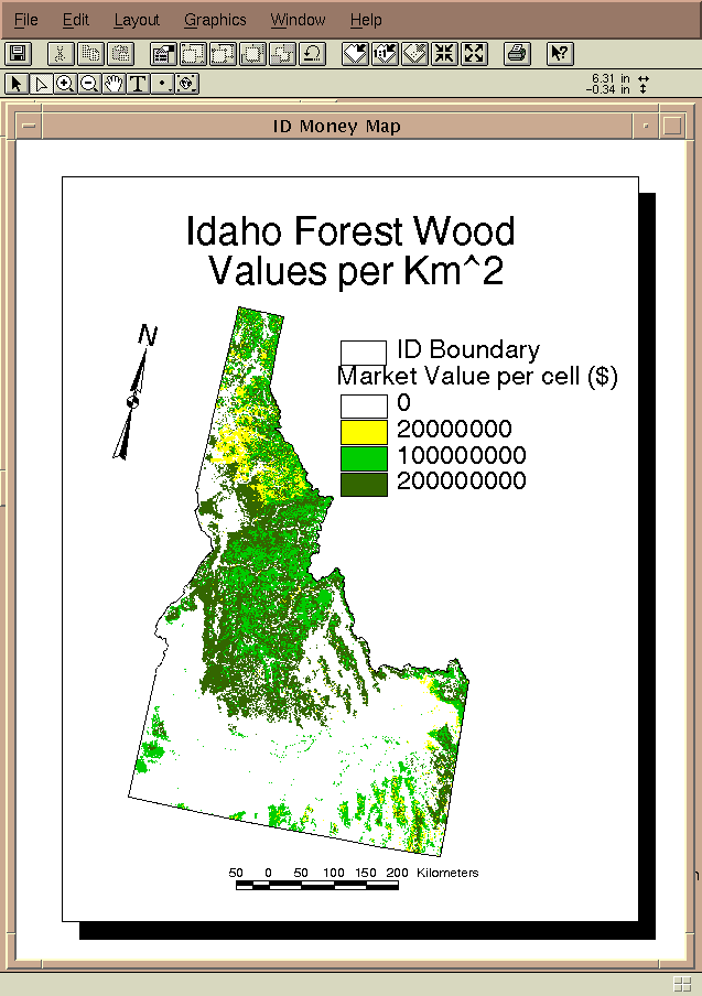
it can then be converted to a forest value map, which is composed of a forest speies map superimposed
with values of each of those corresponding forest species.