The Use of GIS in Wetlands Health Assessment


Table of Contents

Wetland conservation has recently become a major concern of the environmetalist
population. The many benefits derived from wetland ecosystems coupled with the steady
loss of wetland acreage throughout the past century provide the main reasoning behind
this concern. Identifying, classifying, and evaluating wetland regions are becoming
crucial tasks in assessing the current problem and possible remediation strategies.
Recent Federal attempts to regulate wetland destruction and mitigate the effects of
development call for an effective means of analyzing wetlands data. For this reason,
this project is an investigation into the use of GIS as a tool in wetlands evaluation.

Wetland Types
According to the US Army Corps of Engineers and the US Environmental Protection Agency,
wetlands are defined as:
Those areas that are inundated or saturated by surface or ground water at a frequency
and duration sufficient to support, and that under normal circumstances do support,
a prevalence of vegetation typically adapted for life in saturated soil conditions.
Wetlands generally include swamps, marshes, bogs, and similar areas.
(Taken from "Recognizing Wetlands:
An Informational Pamphlet")
To simplify a rather complex definition, a wetland is an area of land that is saturated
or covered with water during the growing season. Unfortunately, problems occur when
classifying an area as a wetland due to changing land conditions and water cover over time.
There is no definitive line between wet and dry environments, as any area will fluctuate
from one to the other in many cases due to seasonal weather changes. Recent governmental
regulation of wetlands has necessitated the derivation of a method for defining wetland boundaries.
Recent governmental regulation of wetlands has necessitated the derivation of a method for
defining wetland boundaries. The US Fish and Wildlife Service, in response to this need,
created a manual for classifying wetlands, titled
"Classification of Wetlands and Deepwater Habitats of the United States." In this
classification system, wetlands are defined and grouped into categories by a number of factors
including substrate material, frequency of flooding, and vegetation. A general schematic of the
classification system is given here:
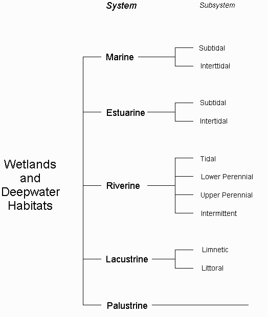
Wetlands Classification Hierarchy
The first level of the classification hierarchy is the wetland system, divided into five sections:
Marine, Estuarine, Riverine, Lacustrine, and Palustrine. Wetlands in the same system have
similar hydrologic, geomorphologic, chemical, and biological characteristics. Each System is
then divided into subsystems, which are dependent on the given system.
Marine The Marine system consists of wetlands along the coastline.
These environments are exposed to the open ocean, so they are strongly influenced by ocean waves
and currents and have high salinities, generally above 30%. The most important factor in this
system is the effect of the tidal waves on the natural habitat and on the water flow regime.
This system is divided into Subtidal and Intertidal subsystems.
Estuarine Wetlands in the Estuarine system include those associated
with both estuaries and lagoons. Estuarine wetlands are open to the ocean, but are generally
semienclosed by land. Because of this, the marine water is somewhat diluted by freshwater
from land runoff or other adjacent freshwater sources, causing salinities to be lower than those
typically found in the Marine system. Estuarine habitats are still influenced by ocean tides,
but to a lesser degree. As in the Marine system, this system is divided into Subtidal and
Intertidal subsystems.
Riverine The Riverine system classification consists of wetlands
and deepwater habitats contained within a channel. Water is generally flowing in this system
due to the presence of the channel. Riverine wetlands are restricted to freshwater flows, so
salinities usually stay below 0.5%. This system is divided into four subsystems: Tidal, Lower
Perennial, Upper Perennial, and Intermittent.
Lacustrine Lacustrine system wetlands are usually located in a
topographic depression or a dammed river valley. This system includes permanently flooded
lakes and reservoirs, intermittent lakes, and tidal lakes. Lacustrine wetlands generally
contain large areas of deep water and are influenced by wave action. As in the Riverine system,
water salinities remain below 0.5%. This system is divided into Littoral and Limnetic subsystems.
Palustrine Wetlands in the Palustrine system are dominated by trees,
shrubs, emergents, mosses, or lichens. These habitats are generally nontidal, but can also be
tidal as long as salinities are below 0.5%. In general terms, the Palustrine system includes
ponds, marshes, swamps, bogs, and prairies. Wetlands in this system are only weakly influenced
by the movement of wind and water. This system contains no subsystems.
These five main systems of wetlands are further divided into classes, subclasses, and dominance
types. Classes and subclasses are determined by the type of material in the substrate and the
general flooding regime or by the type of vegetation present. The dominance type refers to the
dominant plant or animal forms in the given area. This classification system also utilizes
modifiers which denote the water flooding regime, general water chemistry, or soil type. More
details (about 50 pages worth!) on these subsections as well as the entire classification
hierarchy can be found in the manual. (See "
Classification of Wetlands and Deepwater Habitats of the United States.")
Benefits of Wetlands
The primary reasons for recent attempts to protect natural wetlands are the numerous benefits
these habitats incur. Now beyond past decades of draining and clearing wetland areas, their
influences on the natural environment are being more carefully scrutinized as the impacts of
"the four D’s" ("Dike it, dam it, divert it, and drain it!") are being felt. In their natural
state, wetlands provide benefits to the natural environment as well as society, and unfortunately
these are not easily derived from replacements.
Ecological
Wetlands are the natural habitats of thousands of species of fish and wildlife, including
approximately one-third of the nation’s endangered or threatened species. The richness and
diversity of wetland ecosystems have been compared to those of the tropical rain forests, as
they are both considered among the most biologically productive environments in the world.(EPA)
Many more animal species are dependent on the wetlands for seasonal shelter, since these areas
provide ample sources of food and water when other regions’ resources are scarce.
Another important ecological benefit of wetlands is their ability to act as water flow regulators.
Wetland surfaces tend to act like sponges, absorbing water during flood periods and then releasing
it slowly during dry times. Because of this, groundwater and surface waters are gradually
replenished and the effects of drought are lessened. Wetlands also diminish flood effects by
slowing water flow and retaining runoff during periods of high flow. Overall, wetland environments
act as buffering systems, moderating the results of severe weather and climate conditions.(OEPC)
Water quality is also positively affected by the presence of wetlands. Runoff water filtering
through a wetland will be naturally treated for nutrients and sediment, as the plant cover retains
the nutrients, processes the organic wastes, and traps the sediments in the water. In fact,
artificial wetlands are now being created solely to treat various types of wastewater.(OEPC)
Economical
In addition to the vital part wetlands play in their natural ecosystems, these areas also provide
important economic benefits. Commercial fishing in the US is painfully dependent on wetland
environments, as between 60 and 90% of commercial fisheries use coastal wetlands as growth
habitats.(OEPC)
In total, fishery processing and sales in the US in 1991 accounted for $26.8 billion in economic
activity.(EPA) Commercial fur is another important industry dependent on the nation’s wetlands
for harvesting grounds.
Wetlands also provide recreational activities including sport fishing, hunting, bird watching,
and photography. Combined, these activities accounted for $59.5 million in economic activity in
1991.(EPA)
Reasons for Protection
Since the 1700’s, over half of the nation’s wetlands have been lost or destroyed, reducing the
total area from 221 million acres to only 104 million in 1985. The figure below describes the
amount of wetlands acreage lost in each state through the 1980’s. Seven states have lost more
than 80% of their original wetlands coverage.(EPA)
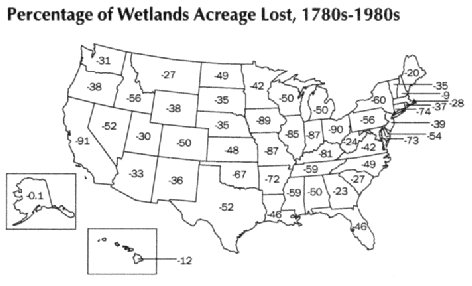
Percentage of Wetlands Acreage Lost
Agricultural development accounts for the majority of wetland conversions, but a growing percentage
is being lost to urban development and commercial activities. As cities and industries expand,
wetland regions provide inexpensive land for development. Since the majority (74%) of wetlands
are privately owned, and few owners of wetlands actually enjoy direct benefits from them, the
wetlands are sold or privately developed.(OEPC)
Some of the results of the loss of wetlands are obvious from the previously mentioned benefits.
Increased flooding and increased severity of flood damage are two important effects. Another
notable effect is the extinction of plant and animal species resulting from the loss of habitats.
Also, as is obvious in many regions around the country, destruction of wetlands results in the
degradation of water quality. Nutrient loadings increase, augmenting the growth of undesirable
weeds and algae. Algae blooms deplete the dissolved oxygen in the water, depriving fish and other
organisms of their natural source of oxygen. Beyond the effects on the ecosystem, drinking water
supplies can become contaminated by increased urban runoff pollutants, normally controlled by the
natural wetlands filtration system.(EPA)
Both the Federal and State governments are taking steps to slow the wetlands degradation process
and prevent the worsening of these adverse effects. This is carried out through land acquisition,
regulation, and mitigation. While land acquisition has been a major staple in preservation
efforts, it remains costly due to the high percentage of wetlands which are privately owned.
Regulation is a more cost effective means, but it remains limited by the lack of universally
agreed-upon terms and definitions, as well as the inevitable bureaucratic delays. Mitigation
calls for the restoration or creation of wetland areas to offset the effects of development.
While this seems to be an ideal way to control wetland losses, problems arise in determining the
success of mitigation efforts and the effectiveness of newly created wetlands. Overall, while the
government is working towards wetland preservation, effective procedures for defining wetland areas
and assessing their health still need to be developed.

NWI Data
The US Fish and Wildlife Service department known as the National Wetlands Inventory (NWI)
is in the process of compiling data on wetland types and areas for the entire United States.
This data set includes location and classification of the wetlands, based on the
classification system derived by the US Fish and Wildlife Service previously discussed.
When completed, NWI hopes to provide coverages for the entire contiguous United States,
Hawaii, Alaska, and the US protectorates in the Pacific and Caribbean.
The predominant source of data for the creation of these coverages and descriptions is
aerial photography, taken in conjunction with the US Geological Survey, the US Department
of Agriculture, and the National Aeronautics and Space Administration. The photographic
sources range in date from February 1971 to December 1992. The maps were created by
manually interpreting the aerial photography supplemented by soil surveys and field checks.
The delineated wetland boundaries were then manually transferred to USGS topographic maps
and labeled. This processing occurred between 1979 and 1992. Digital wetland data is
manually digitized or scanned into topographically correct data files using the Wetlands
Analytical Mapping System. Completed files include planimetric ground coordinates and
wetland classification attributes. This process has been ongoing since October 1981.
The final results are digital line graph coverages divided into individual 7.5 minute
quadrangles. The grid coordinate system is in the Universal Transverse Mercator (UTM)
projection, in zones ranging from 4 to 20 depending on the location. The horizontal datum
referenced is the North American Datum of 1927. A complete listing of an example coverage
description is given below.
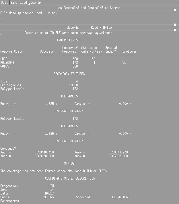
Description of Sample NWI Wetlands Coverage
While fairly detailed wetland coverages are completed for many areas, huge gaps in the
entire nation’s coverage exist. A listing of the status of the NWI digital mapping process
across the United States is shown below. Completed coverages are shown in red.
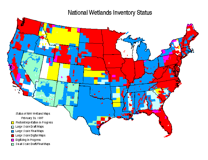
Status of NWI Coverages
Another problem is the potential error associated with
such detailed coverages. Since aerial photography was the primary source of wetland
delineation, the final processed data is only as accurate as the photography. Many
areas have tremendous amounts vegetation, inhibiting the complete and accurate description
of the ground cover, especially the water cover, by photography. Also, some of the
original photography was taken as early as 1971, and land cover can change fairly
drastically in only a few years. Some of this earlier data may not accurately describe
the areas as they exist today. In the future, satellite images may provide the most
accurate and detailed data for specific wetland areas.
Other Related Data Sources
For this project, USGS digital elevation data as well as land use/land cover data were
also used. Digital elevation model (DEM) data are given in 1 degree by 1 degree blocks
(1:250,000 scale). The primary data sources are cartographic and photographic. This
raw topographic data is digitized and then processed into the final coverages. These
include elevations in meters relative to the National Geodetic Vertical Datum of 1929
and geographic coordinates in the World Geodetic System of 1972. Complete elevation
data is available for all of the contiguous United States, Hawaii, and most of Alaska.
Land Use/Land Cover (LULC) data from the USGS were also used in this analysis. This
coverage describes the vegetation, water, and natural surface for a given land area.
The primary source of data is aerial photography, taken from NASA high altitude missions
and other related sources. As in the case of the DEM coverage, the data is digitized
and then processed into a final coverage. The LULC data are similarly in a standard map
scale of 1:250,000. The completed coverages are in the Universal Transverse Mercator
projection system. LULC data are available for most of the contiguous United States and
Hawaii.
The most important data in this analysis is the NWI wetlands classification coverage.
This was also the most limiting data source, since the project is still in the processing
stages in many areas and so complete data is not currently available. The Eastern Texas
shoreline was one region of fairly comprehensive coverage. In relation to other studies
currently being conducted, the Corpus Christi Bay area provided an ideal study area as
far as data availability, size, and application to other research.
While more data is available for the surrounding areas, and a more comprehensive region
study may be more applicable to the objectives of this research, size constraints kept
the study area to a minimum. All of the data utilized here can be found in the NWI
database. The data is divided into directories of 1:250,000 scale map units, labeled
with the titles given to the same regions in the USGS topographic and other coverages.
In this case, the directory was appropriately labeled "corpus_christi." Each directory
contains the 7.5 minute quads for the given region.
Though just one region was chosen for this study, the processing steps are valid for any
region where NWI wetlands classification data is available. Any size region’s data may
be downloaded and analyzed, but memory may prove to be a major constraint. For the Corpus
Christi study area, individual quad coverages ranged in size from as little as 5 Kb to as
large as 821 Kb in their compressed states.
Objectives
The intention of this research project is first and foremost to utilize the NWI wetlands
classification data in a GIS program. In this case, the GIS programs used are Arc/Info
and the associated ArcView. Two of the main components of this project are converting
the original NWI coverages into an Arc/Info coverage and manipulating this new coverage
within the system.
Beyond this initial process, researchers and conservationists are often concerned with
the status of specific wetland types, since each type has unique characteristics and,
therefore, unique benefits and limitations. Different wetland types, for example, are
better at filtering out pollutants, while others may provide more valuable wildlife
habitats. The sensitivities of wetland areas are also dependent on the type of wetland
present. Because of this need to identify regions by wetland type, another goal is to
isolate different wetland classifications into individual coverages.
In order to assess the relative health of a wetland environment, pertinent data such as
elevation, land cover, soil type, and precipitation are also needed, especially in a
historical sequence. These data sources depict changes in the wetland characteristics
over time. For this reason, a third objective of this research is to find a relatively
easy method of editing related data coverages by wetland class. The combination of these
steps should facilitate the assessment of the status of a specific wetland type in a given
region.
Step 1: Obtaining NWI Data
NWI wetlands classification data can be obtained in digital line graph format from the
NWI web site (ftp://www.nwi.fws.gov/dlgdata/).
Only the name of the USGS 1:250,000 scale map unit needs to be known
initially, as this is the directory name where the individual coverages are found. The
text file in each directory contains a listing of the 7.5 minute quads in that region.
Once the correct directory and files are found, the files can be saved directly into a
chosen directory by simply clicking on the file name. These files can also be accessed
directly through FTP. For more information, see the README in the original /dlg/
directory.
The files will appear as filename.tgz. Each consists of two separate files that are
"tar"ed together and compressed using the gzip utility. Both tar and gzip can be obtained
directly from the NWI site (ftp://www.nwi.fws.gov/software/).
The files first need to be unzipped by typing the command:
gunzip filename.tgz
This step results in a file titled filename.tar. The uncompressed file can be un"tar"ed
by typing:
tar xvf filename.tar
The final result is two files labeled filename.dlg (the digital line graph data) and
filename.att (the wetlands attribute data).
Step 2: Converting to an Arc/Info Coverage
In order to more easily convert these two files into an Arc/Info coverage, NWI provides
a series of AML’s (Arc Macro Language files). These can be downloaded directly from the
NWI site (ftp://www.nwi.fws/software/amls).
There are six files in total that need to be downloaded:
dlg2arc.aml
dlg2arc.menu
dlglaunch.aml
dlgconvert.aml
dlgmajor.aml
dlgbuild.aml
These files must be in the same directory as the data files. All files and directories
used should be in lower case lettering to prevent errors when using the Arc/Info program.
Also, the AML file names need to be listed exactly as they appear here, despite the titles
that appear when they are downloaded.
Once the files are properly copied and in the same directory a convertlist file must be
created. This file should simply contain a single column containing the data filenames
(prefixes only). There can be no extraneous spaces after the filenames, as the AML’s
look for files with the precise prefix typed in the convertlist file. After the list
is completed, "end" should be typed at the bottom of the list. This signals to the
programs that the list is completed. A sample convertlist file is given here:
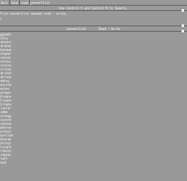
Sample Convertlist file
Once this file is saved (also in the same directory) the primary AML can be run within
Arc/Info. Arc/Info should be opened by typing arc at the prompt, then the AML can be
run by typing at the Arc prompt:
&r dlg2arc.aml
The program will open with a menu (dlg2arc.menu) and, to begin, option 1 should be
chosen (dlg2arc.aml). For this project, the ATP files, which are specific versions of
the attribute files, that are mentioned at the next prompt are not used. The program
will then run, outputting the interface for each converted file into an error file called
dlg.errors. After the program has completed its conversions, this error file should be
checked to make sure there were no problems. A primary source of error here are a lack
of exact filename matches between the desired files as listed in the convertlist file and
actual file names. Another possible error may occur if capital letters are used in the
directory or file names. If errors are encountered, the above steps need to be retaken
until the AML has properly completed its conversions.
Once all of the desired files have been processed, each original data file should now have
two associated directories:
filenamenwic
filenamenwip
These are the line and point coverages, respectively. The AML now needs to be rerun,
this time choosing option 2 (dlgbuild.aml). This finishes the processing by building
the polygon coverage for each file name, deleting the point coverage directory, and
leaving a final directory called filenamenwic for each coverage. These can be
brought up individually in ArcView or altogether, but each 7.5 minute quad coverage remains
an individual theme. The results of the above processing on the Corpus Christi region data
are shown here as an ArcView layout:
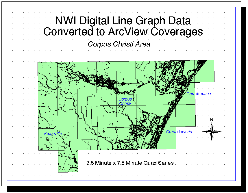
Converted NWI Digital Line Graph Data
By examining the converted polygon coverages in ArcView, it can be seen that the
individual coverages need to be combined into one comprehensive coverage to successfully
analyze a region. As the coverages now exist, each quad can be depicted by wetland
type, but the depiction in ArcView differs for each quad since they are currently separate
themes. In other words, Marine wetlands may show up as one color in one quad and another
color in a different quad. This creates problems when trying to analyze a larger region
consisting of multiple quads. For this reason, the individual coverages need to be joined
into one coverage. This can be accomplished in Arc/Info by using the mapjoin command.
While mapjoin can in some cases be used successfully on coverages as they appear directly
after conversion, problems may be encountered if quads are adjacent and border segments do
not exactly match. For this reason, the coverages should be cleaned before using mapjoin.
This intersects points and lines, reassembles the polygons, and rebuilds the attribute
tables. Once in the Arc/Info Program (type arc), the following command should be typed:
clean incover outcover
After each of the polygon coverages has been cleaned, mapjoin can be run by typing:
mapjoin outputfile
The program will then prompt the user for the names of the coverages to be joined.
A blank line is entered when all of the coverages have been inputted, as this signals
the program that the file list is complete. Up to 500 different coverages can be joined
at once, but memory tends to exceed easily in this program. If a memory error
is encountered, the number of coverages joined at once should be reduced.
If the mapjoin process is successfully completed, the final dialog statement should
be "Creating PAT..." and the program should return to the Arc prompt. If the
program begins to create the PAT (polygon attribute table) but encounters an error and
outputs the error message
COULD NOT DEFINE OUTPUT FAT
UNABLE TO CREATE FAT FILE
then the program will abort and no output coverage will be created. This is most likely
due to errors in the output coverage name or in the input coverage names. No numbers or
capital letters should be used in either. If these problems are corrected and the error
message still appears, the name of the output file should be varied until the program
successfully completes.
Another possible error may occur if there are problems in the input coverages. If the
program reaches a point where it is "Assembling polygons..." but encounters an error and
outputs the error message
FATAL ERROR
Mismatch of border segments (NODPOL)
then the borders of adjacent coverages are not meeting. The input coverages should be
cleaned to remedy this before attempting to use mapjoin.
Once mapjoin has been successfully completed, the section borders can be dissolved
to create one comprehensive coverage. This is done by typing:
dissolve incover outcover attribute poly
This dissolves the input coverage by the attribute characteristic to create the output
coverage. A sample Arc/Info dialog is for the entire procedure is listed here:
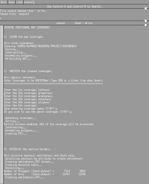
Sample Arc/Info Dialog for Joining Coverages
Once these steps have been completed, the final comprehensive coverage can be opened
and viewed in ArcView. The resulting coverage of the eastern half of the Corpus Christi
study area is shown in an ArcView layout:
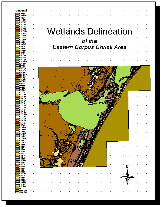
Joined NWI Wetland Coverages
After successfully creating a complete region coverage, the next step is to isolate
specific wetland types in Arc/Info. This can most easily be done by first working
with the coverage in ArcView. The ArcView program should be opened (type arcview)
and the coverage should be added as a theme in a new view. The theme will appear as
a single color with various lines overlaid. The legend for this theme should be
altered so that Unique Value is shown attached to the value field Attribute. An
array of colors should now appear in the theme, each one associated with a specific
type of wetland, listed as a series of letters and numbers that can be interpreted
based on the Wetlands Classification Hierarchy. To isolate a certain type of wetland,
the Query option should be chosen under Theme/Properties on the menu bar.
The theme should be queried in the form of the following statement:
(Attribute = AAAAA) or (Attribute = ABBBB) or ...
where AAAAA and ABBBB are the chosen wetland classification abbreviations. Once the
query is completed the revised theme should display only those wetland types chosen.
Additional queries can be made on the revised theme, if needed. Once the desired wetland
types have been properly isolated, the resulting theme should be converted to a shapefile
by choosing Theme/Convert to Shapefile from the menu bar.
After the shapefile is created, Arc should be opened and the shapefile should be converted
into an Arc coverage by typing the following command at the Arc prompt:
shapearc incover outcover
The isolated wetland types now stand as their own separate coverage. To make sure
segments and polygons are properly joined, the new coverage should be cleaned by typing:
clean incover outcover
This new coverage can now be used to view in more detail the specific wetland types
in a given region. Also, the shapefile created in the process, basically an outline
of the area covered by that wetland type, can be used to edit other data coverages.
A sample dialog of the above steps is given here:
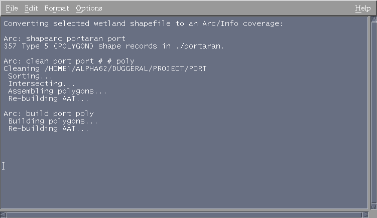
Sample Arc/Info Dialog for Isolating Wetland Types
For this and all remaining parts of the project, the study area, previously the entire
Corpus Christi 1:250,000 cell block, is reduced to a single 7.5 minute quad, the Port
Aransas quad. This is done for memory purposes and to enable more detail to be viewed.
The above steps were performed on the Port Aransas quad, isolating only the Estuarine
wetlands. The results are shown here in an ArcView layout:
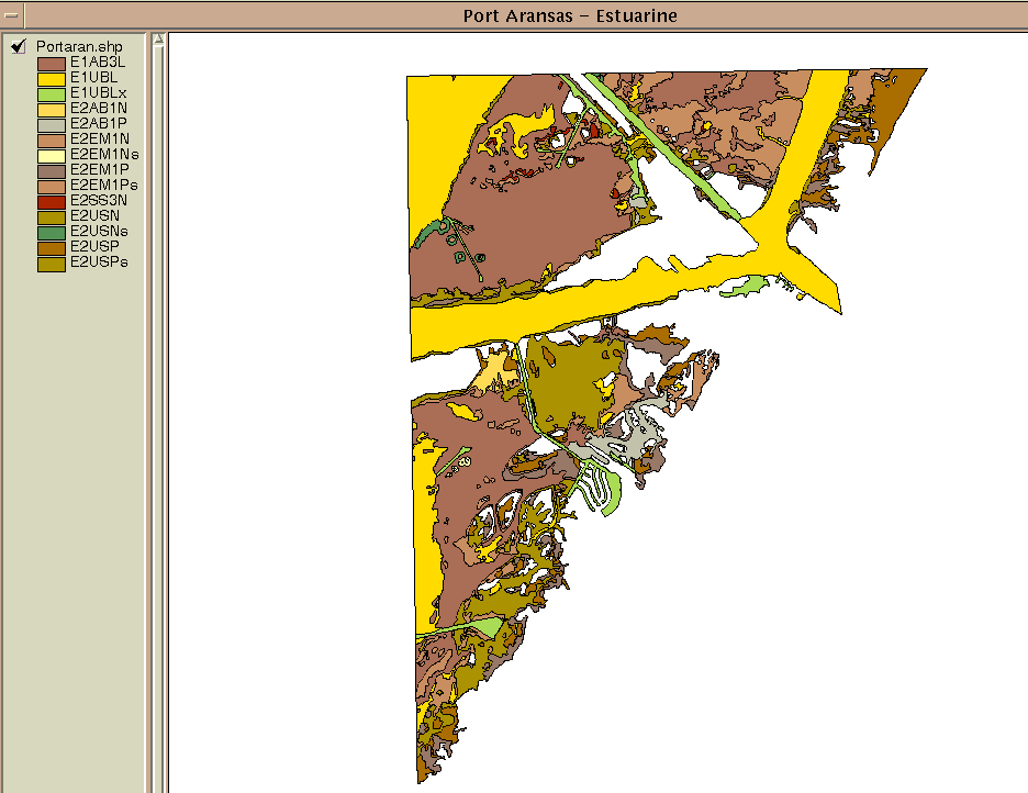
Isolated Estuarine Wetlands of Port Aransas
Land Use/Land Cover Data
Land Use/Land Cover data for a given area can be quickly downloaded from the USGS
web site (http://sun1.cr.usgs.gov/doc/edchome/ndcdb/ndcdb.html).
The data must then
be converted into an Arc/Info coverage. For steps in this process, see
Dr. Maidment’s
Home Page.
For the desired wetland type previously isolated, related data can be clipped to the
same covered area. This enables the wetland coverage and the related coverage to be
readily compared by displaying only the data for those areas covered by the specific
wetland type. This process is done rather easily with the USGS Land Use/Land Cover data.
Since this data is already in UTM projection coordinates it needs only to be clipped
with the desired wetland coverage. This is accomplished by typing the following command
at the Arc prompt:
clip incover clipcover outcover poly
This clips the input coverage with the clip coverage to create an output coverage.
The final coverage can be cleaned if necessary and displayed in ArcView. It should have
the same shape as the coverage obtained in the previous section. This newly created land
use map can now be studied to determine the relationship between land cover and the
particular wetland type. Results of these steps when applied to the Port Aransas
Estuarine Wetland Region are given here as an ArcView layout:

Land Use/Land Cover Data for Port Aransas Estuarine Wetlands
Digital Elevation Models
Digital Elevation Models can be downloaded from the same USGS web site
(http://sun1.cr.usgs.gov/doc/edchome/ndcdb/ndcdb.html).
The data must then be converted into an Arc/Info
coverage. For steps in this process, see
Dr. Maidment’s
Home Page.
DEM’s provide slightly more of a challenge since they are not in UTM projection
coordinates. This means the DEM must be projected into these coordinates within the
Arc/Info program. This is accomplished in Arc by typing the following command at the
Arc prompt:
project grid ingrid outgrid projectionfile
This step projects the input grid into the coordinate system specified by the projection
file and creates an output grid. The projection file must specify the coordinate system
of the original DEM as well as the coordinate system of the desired projection. If the
coordinate system for the DEM is unknown, it can be determined by describing the grid as
is done by typing:
describe gridname
The projection file used to project the USGS DEM into UTM coordinates is listed here:
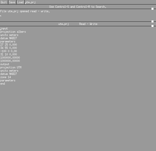
UTM Projection File
Once the projection has been successfully completed, the grid must be clipped to
contain only those areas of the desired wetland type cover. This is a similar process
to the clipping procedure used on the Land Use/Land Cover data. Instead of clip gridclip
is used in the Grid system. At the Arc prompt, grid should be typed to open the Grid
system. Then the DEM can be clipped by using the gridclip function, accessed by typing
the following command at the Grid prompt:
gridclip ingrid outgrid cover clipcover
This statement instructs the program to clip the input grid with a coverage, the
clip coverage, to create an output grid. Once this step is accomplished, the final
clipped grid can be viewed in ArcView. As with the land use data, the final grid should
cover the same area as the original wetland type coverage.
The Arc/Info dialog for clipping both the Land Use/Land Cover data and the DEM
is listed here:
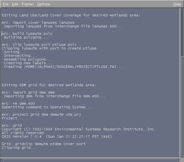
Arc/Info Dialog for Clipping Coverages
The intentions of this research project were to effectively utilize the National Wetlands
Inventory wetlands classification data in a GIS program and to show some of its potential
applications. The NWI data provides detailed if not comprehensive coverages of wetland
types for certain sections of the United States. Though the database is not complete, it
has the potential to become a source of valuable data for wetlands research and
conservation studies.
One of the main reasons for bringing this data into a GIS program such as Arc/Info is to
be able to readily manipulate and display the data, but another application is to link the
wetlands data to other sources and be able to successfully compare the two. This process
is crucial in attempting to asses the general state of the wetland region as a whole or
the relative health of specific wetland types in the region. In this Arc/Info procedure,
the basic steps for beginning a GIS analysis of regional wetlands data for the purpose of
assessing health are outlined. These steps successfully created a comprehensive Arc/Info
coverage, isolated specific wetland types in the coverage, and edited other related data
sources for the chosen wetland types. The results were shown in maps that can be readily
analyzed and compared.
Though the GIS portion of this project was successful, more work needs to be done before
an accurate assessment of wetland health can be conducted. Other parameters such as
historical land cover and water quality would augment this study by providing more
detailed descriptions of the wetland regions. These data types could potentially be
processed the same way the Land Use/Land Cover data and DEM’s were processed, resulting
in easily comparable coverages for the study region.
Though this analysis was applied only to a small region, the Corpus Christi Bay area,
the potential exists for use on a much larger scale. Once the NWI classification data
is in its completed digital form for the entire Untied States, the GIS applications and
their effects on the movement towards wetlands conservation and mitigation will be
tremendous. GIS will provide not only a means of assessing the health of natural
wetlands, but also the results of current attempts to create new wetlands and their
impacts on the ecosystem as a whole.
 Return to Title Page
Return to Aubrey's Home Page