 |
Elevation | |
|
Elevation | |
Throughout North America wolves are known to have lived at most elevations, from sea level to over 10,000 feet. In the arid Southwest and Northern Mexico, however, wolves were less common at lower elevations and lived primarily in montane areas. Higher elevations generally receive more precipitation, which in turn supports greater biomass of vegetation and thus more deer and other herbivores upon which wolves prey. Though estimates vary, most wildlife biologists agree that somewhere between 3,500 and 4,000 feet is the elevation threshold below which wolves seldom frequented.
This fact begs the question: What percent of the Big Bend Wolf Recovery Area is above and below this elevation threshold?
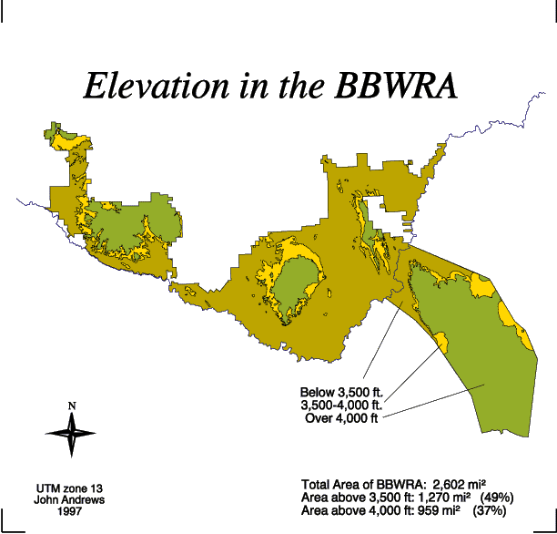
...and on the map above are the answers.
The steps I took to create this map are as follows:
- First, from TNRIS I downloaded two 1:250,000 DEMs which cover the Big Bend Wolf Recovery Area.
- I then converted the DEMs to lattices and merged them into one file.
- In ARC/View I generated a 3,500 and 4,000 foot contour line using spatial analyst, and then converted these contour lines into shapefiles.
- In ARC I converted these shapefiles to arc coverages--I named them 35line and 40line--and then clipped them with my parks boundary file (parks4).
- Next, I copied the coverage parks4 twice. I renamed one coverage 35ft and the other 40ft. In ARC/Edit I opened the coverage 35line, selected all of the arcs, and put them into the coverage named 35ft. Likewise, I opened the coverage 40line, selected all of the arcs, and put them into the coverage named 40ft.
- I opened each of these coverages (35ft and 40ft) in ARC/Edit, set the draw environment to 'node dangle,' and proceeded to clean up the coverages.
- I then built each of these coverages to establish polygon topology.
- At this point I had the three polygon coverages I needed to work with: parks4, 35ft, and 40ft. In ARC/View I opened a view window and added these three coverages to the display. In the theme bar I selected the coverage parks4 and then opened its polygon attribute table. The coverage consisted of only one polygon; I wrote down the value displayed in the column 'area' and then closed the table.
- Next, I selected the coverage 35ft in the theme bar and opened its polygon attribute table. This coverage consisted of numerous polygons, so I had to select the column 'area' in the polygon attribute table and then calculate the statistics for that column. I wrote down the value for total area and then closed the table.
- I followed this same step for the coverage 40ft.
- Because the map units for each of these coverages was in meters, I had to convert the values I had written down from square meters to square miles. The total area of the Big Bend Wolf Recovery Area is 2,602 square miles. Of this total, 1,270 square miles, or 49% of the recovery area, is above 3,500 feet in elevation. Only 959 square miles, or 37% of the recovery area, is above 4,000 feet in elevation.