![]() Procedure
Procedure
![]() Procedure
Procedure
![]()
The data were accessed from miscellaneous sources:
![]() Discharge points, locations were release of wastewater is allowed in Texas, are available at the ftp site ftp.tnrcc.state.tx.us, at the location /pub/WaterResourceManagement/WaterQuality/TMDL/dischpts.e00
Discharge points, locations were release of wastewater is allowed in Texas, are available at the ftp site ftp.tnrcc.state.tx.us, at the location /pub/WaterResourceManagement/WaterQuality/TMDL/dischpts.e00
![]() Water Right locations in Texas are available at http://www.tnrcc.state.tx.us/gis/sites.html
Water Right locations in Texas are available at http://www.tnrcc.state.tx.us/gis/sites.html
![]() Water Quality Segment points for Texas are available at the ftp site ftp.tnrcc.state.tx.us, at the location /pub/WaterResourceManagement/WaterQuality/TMDL/segsfy99.e00
Water Quality Segment points for Texas are available at the ftp site ftp.tnrcc.state.tx.us, at the location /pub/WaterResourceManagement/WaterQuality/TMDL/segsfy99.e00
![]() USGS Flow Gage locations are available at http://txwww.cr.usgs.gov/txnwis/html/tx.index.ByHUC.html, there they are sorted by HUC codes
USGS Flow Gage locations are available at http://txwww.cr.usgs.gov/txnwis/html/tx.index.ByHUC.html, there they are sorted by HUC codes
![]() Surface Water Quality Monitoring Stations are available at http://www.tnrcc.state.tx.us/gis/sites.html
Surface Water Quality Monitoring Stations are available at http://www.tnrcc.state.tx.us/gis/sites.html
![]() River Reach File 3 is available at http://www.epa.gov/OST/BASINS/STATES/TX/
River Reach File 3 is available at http://www.epa.gov/OST/BASINS/STATES/TX/
![]() Digital Raster Graphics were available through a web page location but it is closed now. However most of the 1:24,000 DRGs have been copied and are at CRWR.
Digital Raster Graphics were available through a web page location but it is closed now. However most of the 1:24,000 DRGs have been copied and are at CRWR.
![]() 90m DEMs are available at http://edcwww.cr.usgs.gov/doc/edchome/ndcdb/ndcdb.html. It is good to choose ftp via graphics, then the right one-degree quad sheets can be selected for downloading by clicking a map. For doing this is, a map of the counties for the area where DEMs are needed is convenient, following is a map of the counties of Trinity Basin:
90m DEMs are available at http://edcwww.cr.usgs.gov/doc/edchome/ndcdb/ndcdb.html. It is good to choose ftp via graphics, then the right one-degree quad sheets can be selected for downloading by clicking a map. For doing this is, a map of the counties for the area where DEMs are needed is convenient, following is a map of the counties of Trinity Basin:

The DEMs and RF3 files came in geographic coordinates, the point layers came in TSMS Albers projection, while the DRGs are in UTM 15 projection. Since for to viewing and working with all the data in Arc View the same projection for all data is necessary, the data layers have to be projected in Arc Info. The final outcome is supposed to be in TSMS Albers, however a projection of the DRGs is not practical (large files). Therefore, for the building of river network with assistance from DRGs the data have to be projected to UTM projection in the meantime.
![]() Geographic coordinates can not be called a map projection. They do however describe locations of the center of the Earth in terms of degrees of latitude and longitude, a reference system that measures angles from the center of the Earth.
Geographic coordinates can not be called a map projection. They do however describe locations of the center of the Earth in terms of degrees of latitude and longitude, a reference system that measures angles from the center of the Earth.
![]() Albers Equal Area projection is a projection in which the areas of all regions are shown in the same proportion of their true area
Albers Equal Area projection is a projection in which the areas of all regions are shown in the same proportion of their true area
![]() UTM, Universal Transverse Mercator projection is series of projections around the world that preserve angles, each spanning six degrees of longitude and oriented to a meridian. For the Trinity Basin UTM 15 is used which means that the central meridian is at -93 W
UTM, Universal Transverse Mercator projection is series of projections around the world that preserve angles, each spanning six degrees of longitude and oriented to a meridian. For the Trinity Basin UTM 15 is used which means that the central meridian is at -93 W
The 90m DEMs were downloaded from the USGS EROS site and unzipped using Winzip
They were converted to Arc Info grids using "Arc: demlattice inputname outputname"
Separate DEMs were merged using "Grid: ouput = merge(input1, input2, input3, ...)"
The resulting grid was converted to an integer grid by using "Grid: outputgrid = int(inputgrid)"
Then the grid was cut down to the extent of the Trinity Basin by using a predefined frame describing the boundary of the basin, "Grid: OutputGrid = selectpolygon (InputGrid, basin_frame, inside)
Finally the grid was projected into TSMS Albers projection
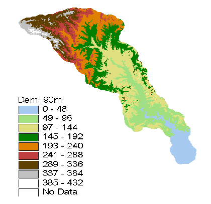
The resulting DEM is shown on the following picture
In flat areas, watershed delineation from raw DEMs is sometimes difficult since the delineation relies on "water streams down the hill". Meanwhile, in flat areas the elevation gradient is so small that the water sometimes gets confused and does not necessarily stream in the "right" direction.
ANUDEM, is an Australian program that might be helpful when dealing with DEMs in flat areas. It has however not been tried out on the Trinity River Basin yet, since the river network for the basin is not ready.ANUDEM can take DEMs, sink points, streamlines, contour lines and lake boundaries as input and give back a DEM where all those data have been taken into account. Also, it can calculate drainage constraints directly from the stream line data i.e. let the stream line data describe in what direction the water wants to flow.
Four of the point coverages are ready to be viewed in Arc View as soon as they have been downloaded, while the USGS flow gage locations are only available as a text. Therefore, some procedure has to be followed to make an Arc View coverage out of them. A good way to do this is to do the following:
Create an excel spreadsheet with the columns: Station-id, longitude (decimal degrees), latitude (decimal degrees) and write the word 'end' in the first cell after the last entry
Save the spreadsheet as a CSV file
Bring the CSV file up in Notepad; delete commas after end, save the file as a text file (txt)
In Arc Info create a point coverage:
Now the usgsgages coverage is ready to be viewed in Arc View
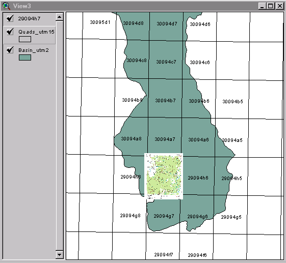
The river network is primarily based on the EPA RF3 database, therefore the first step was to download the RF3 file from the EPA web site, project it and view it in Arc View. The Rf3 file is however not alone suitable for watershed delineation since it has complicated features like braided rivers and also water bodies like lakes for this reason the river network has to be simplified.
By using the query builder in Arc View certain reach types were selected, R, i.e. a regular river segment that has upstream and downstream reaches connected to it. And S a regular river segment which has no reach upstream. The third type selected was T; i.e. a regular river, which has no reach downstream, connected to it. No T reach types were found but the others form the blue lines on the following picture. As can be seen on the picture, the reach type query took the braided river out and left a gap where the river was before. It is not good however to have a gap instead of a braided river, therefore the USGS centerline coverage was added to the network.
The centerline coverage is a set of interpolated line transport paths through all the water bodies, i.e. a single line instead of a braided river and lines through the lakes. Even though the centerline coverage usually coincides with the simplified RF3 network, there is often a small gap where a centerline and a RF3 line meets. To find those gaps, a script can be run to identify the dangling nodes, and then by using the editing mode in Arc View the two lines can be connected.
This process still leaves some strange features and unconnected lines, which is hard to correct when using the line coverage alone. Therefore Digital Raster Graphics, i.e. digitized topographic maps of Texas, available at TNRIS, were added to the view in Arc View. By laying the river coverage over those maps a more complete understanding of the lines can be accomplished and a determination of how corrections are to be done is easier.
The following picture describes this process:

To make it easier to add the topographic maps to the view i.e. not always having to look up the name of each map, click "Add theme" and search for the right file, it is good to use the "Hot Link" button in Arc View!
![]()
To use this option, "Hot Link" a reference grid has to be used, I took a 7,5 minute grid, "Quads". In the grid, each cell corresponds to one topographic map. In the quads attribute table, a field has to be added connecting the cells to the file names of the corresponding maps.
The next step is to write an appropriate script, that is tell the computer what you want it to do when you click a cell in the grid. Right now my script searches for the right file, if it does not find it, it gives the name of the CD to be inserted. Then it adds the right map to the view and zooms in.
However, when starting Arc view the "Hot Link" button is dimmed, to be able to use it the right theme has to be active, then theme properties has to be clicked and the topic "Hot Link" has to be selected. Then the name of the field with the filenames has to be selected in the field cell. In the "Predefined Action" cell, "Link to User Script" is selected if you want to use you own script. Finally the rights script in the script cell is picked and the OK button is clicked.
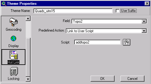
Now, when a cell on the map is clicked, the right topographic map appears.
![]()