Food Visualization on
TINs
By Esteban Azagra and David R.
Maidment
University of Texas at Austin
Center for Research in Water Resources
INTRODUCTION
Floodplain delineation is accomplished by plotting water surface elevations previously calculated with hydraulic models, and different approaches have been attempted to automate the floodplain mapping process. The goal seems to have been successfully achieved with AvRAS, an ArcView extension created by the ESRI, which links the HEC-RAS hydraulic model with the ArcView GIS environment.
The degree of detailed terrain information required when using AvRAS is very high for two reasons:
· Within the stream channel, the information is used to extract the geometric data required by the hydraulic models. This data includes terrain cross-sections along the stream, stream centerline, banks, floodplain boundaries, culverts, bridges, etc.
· Outside the stream, a detailed representation of the reality is necessary to identify the structures and facilities affected by the water such as buildings, roads, railroads, etc.
This large amount of information can be handled with a
triangulated irregular network data model (TIN), which allows an efficient
surface model generation to analyze and display terrain. AvRAS can extract the
information contained in the TIN, export it into HEC-RAS, read the results of
the hydraulic model and represent the flooded areas in ArcView.
CURRENT RESEARCH
The Center for Research in Water Resources (CRWR) is currently conducting a research project in flood visualization. The sample area chosen for the analyses is the Waller Creek Watershed, located in the City of Austin, TX.
Data available for the area was provided by CAPCO for whom it was prepared by ASI. These data include digital information in GIS format for buildings, utilities, transportation, etc., together with a TIN for the terrain with enough detail to achieve an acceptable representation of the terrain. A digital orthophoto for better identification of facilities is also available.
With this data, the CRWR has been able to prepare a pilot model for a portion of the Waller Creek watershed. Up to this point of the research some problems have already been identified.
HEC-RAS requires detailed terrain information to define the geometry of the channel. This information includes the stream centerline, the left and right banks, the floodplain boundaries and a series of cross-sections along the stream. Although AvRAS extracts this information automatically from the TIN, the lack of digital information on the locations of the banks and floodplain boundaries, required a visual interpretation and a manual delineation of these lines from the orthophotos. The results of this delineation appear in Figure 1.
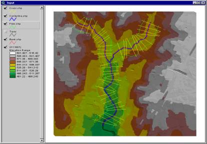
Figure 1.- Stream centerline, banks, floodplain boundaries and cross-sections.
Once the data has been exported to HEC-RAS, it is easy to see how the mentioned visual interpretation induces errors in the results. Figure 2 shows the wrong location of the banks (red points), with the arrows indicating the correct ones.
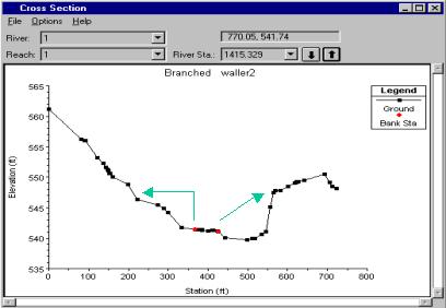
Figure 2.- Typical cross-section with banks wrongly located.
The definition of cross-sections is also accomplished manually. Apart from the cross-sections placed along the stream to define the geometry of the channel, it is necessary to locate cross-sections just before and after structures such as bridges, so these can be properly included in HEC-RAS. This requires a more detailed TIN than the one currently used. The faces of the bridge - the ones perpendicular to the channel - should be represented as nearly vertical faults (since functional surfaces are capable of storing only one z value for a given x, y location). As illustrated in Figure 3, this representation is not very realistic right now because a smooth slope upstream and downstream of the bridge can be seen. Better results could be achieved by defining breaklines parallels to the existing ones at the top of the bridge, with the z values of the bottom.
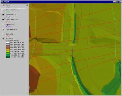
Figure 3.- Detail of a bridge defined by the TIN.
A problem similar to the one just explained occurs with the representation of buildings. Up to this point, buildings have been included as “floating entities” which do not affect the geometry of the terrain, but this assumption is not very realistic. Buildings are artificial barriers for the water, which can considerably affect flooding events. Therefore, they should be treated as interruptions in surface smoothness such as hard breaklines, forming part of the TIN of the terrain.
Digital information available for the buildings on the study area includes a coverage with a series of polygons representing the footprint of the building, as well as information with the elevations to be assigned to each buildings. The CRWR is developing a methodology to insert these buildings into the TIN, but the degree of detail that can be expected is not as good as the one achieved by others TIN already built for other locations of the country. Obtaining a more realistic TIN including buildings and other facilities would be really interesting for the purpose of this investigation.
Despite the difficulties encountered, the research group has come up with positive and encouraging results.
Floodplain representation can be successfully accomplished using AvRAS and HEC-RAS as shown in Figure 4 and Figure 5.
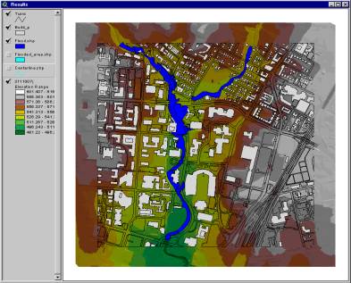
Figure 4.- 2D floodplain representation.
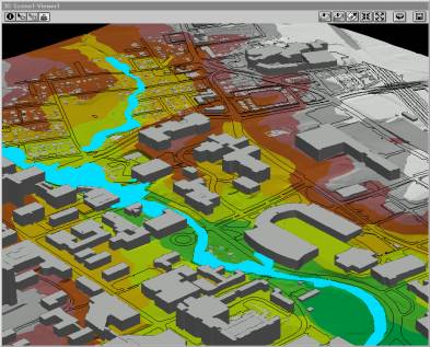
Figure 5.- 3D floodplain representation.
The results obtained from this kind of analyses can be easily converted into 2D and 3D animated movies to show how the water level is rising and falling with time at the different locations. Examples of these animations are included in files attached to this document.
CONCLUSIONS AND DATA REQUIREMENTS
As already indicated in the document, results from the research show that floodplain representation can be successfully accomplished using AvRAS and HEC-RAS.
The key point for achieving accurate results is the availability of detailed data, which in this case means having access to an appropriate TIN of the terrain, which can be obtained from a better interpretation of the terrain data. The precise inclusion into the TIN of any building, bridge, and other facility that would affect the movement of the water, or whose representation is desirable for planning or security purposes, is a priority.
Finally, if the information related to the location of the stream centerline, stream banks and floodplain boundaries can be supplied in a GIS format, the delineating process would be greatly improved, not only in terms of velocity but also - and most important - in terms of accuracy.
Prepared by Esteban Azagra
10 September 1999