INTRODUCTION
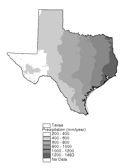
Water availability is critical to the economy in the state of Texas. Numerous reservoirs and conveyance structures have been constructed across the State to meet the water supply needs of farmers, municipalities, industries, and power generating facilities. Despite this extensive water management system, water supply remains a concern because of increasing populations and uncertainties about climate stability. The rainfall map of Texas shown in Figure 1.1 clearly shows that water management is a spatial problem. The State as a whole receives about 711 mm year-1 of rainfall, while the area of the State east of the 100th meridian receives 890 mm year-1 and the area west of the 100th meridian receives only 457 mm year-1. In addition to water supply concerns, the assessment of non-point source pollution is another important issue that is largely dependent on the spatial distribution of runoff. Although, the focus of this report is not to address water supply or pollution issues directly, an improved understanding of the spatial water balance - the partitioning of precipitation between evaporation, runoff, and groundwater recharge at different points in space - will directly benefit those who wish to assess water resource availability and non-point source pollution potential across the State.
The goal of this study was to gain an improved understanding of the stocks of water in different components (air, soil, water bodies) of the hydrologic cycle and the fluxes between these components. A basic approach for determining stocks and fluxes involves the calculation of a water balance. A water balance, applied to a particular control volume, is an application of the law of conservation of mass which states that matter cannot be created or destroyed. To achieve a balance, the rate of change of storage of water within the control volume must be equal to the difference between its rates of inflow and outflow across the control surface. In this study, three independent water balance models were constructed to model different components of the hydrologic cycle - an atmospheric water balance, a soil-water balance, and a surface water balance. These models were constructed using a geographic information system (GIS). A GIS provides a framework for storing and manipulating spatial data and facilitates modeling on control volumes of various sizes and shapes. In all three cases, the choice of modeling unit was driven by the resolution and characteristics of the input data. The control volumes for the atmospheric, soil, and surface water balance models respectively are (1) an imaginary column confined horizontally by the boundary of Texas and extending to the 300 mb pressure level, (2) 0.5° cells with a depth equal to the plant-extractable water capacity of the soil, and (3) 166 gaged watersheds of differing sizes and shapes. Neither the atmospheric nor the surface water balance involve any simulation of physical processes and are simply mass balances based on empirical data. The soil-water balance does attempt to simulate evaporation from the soil through the use of a soil-moisture extraction function. Both the atmospheric and soil-water balance models are time-varying models, while the surface water balance model is steady-state and uses an empirical relationship to estimate mean annual runoff and evaporation in ungaged areas. One advantage of making three independent water balance calculations is that checks for consistency can be made among the three models. For example, all three models yield an estimate of actual evapotranspiration which is a difficult quantity to estimate, particularly at the regional scale. Previous studies at the scale of Texas have estimated only evaporation from open water surfaces and potential evapotranspiration from the land surface (TDWR, 1983; Dugas and Ainsworth, 1983).

Figure 1-1: Mean Annual
Rainfall in Texas from Oregon
State PRISM Study (Daly, 1994)